London will see a ‘Carnival Against Capitalism’ take place in 9 days time to coincide with the 39th G8 Summit taking place in Northern Ireland from 17th to 18th.
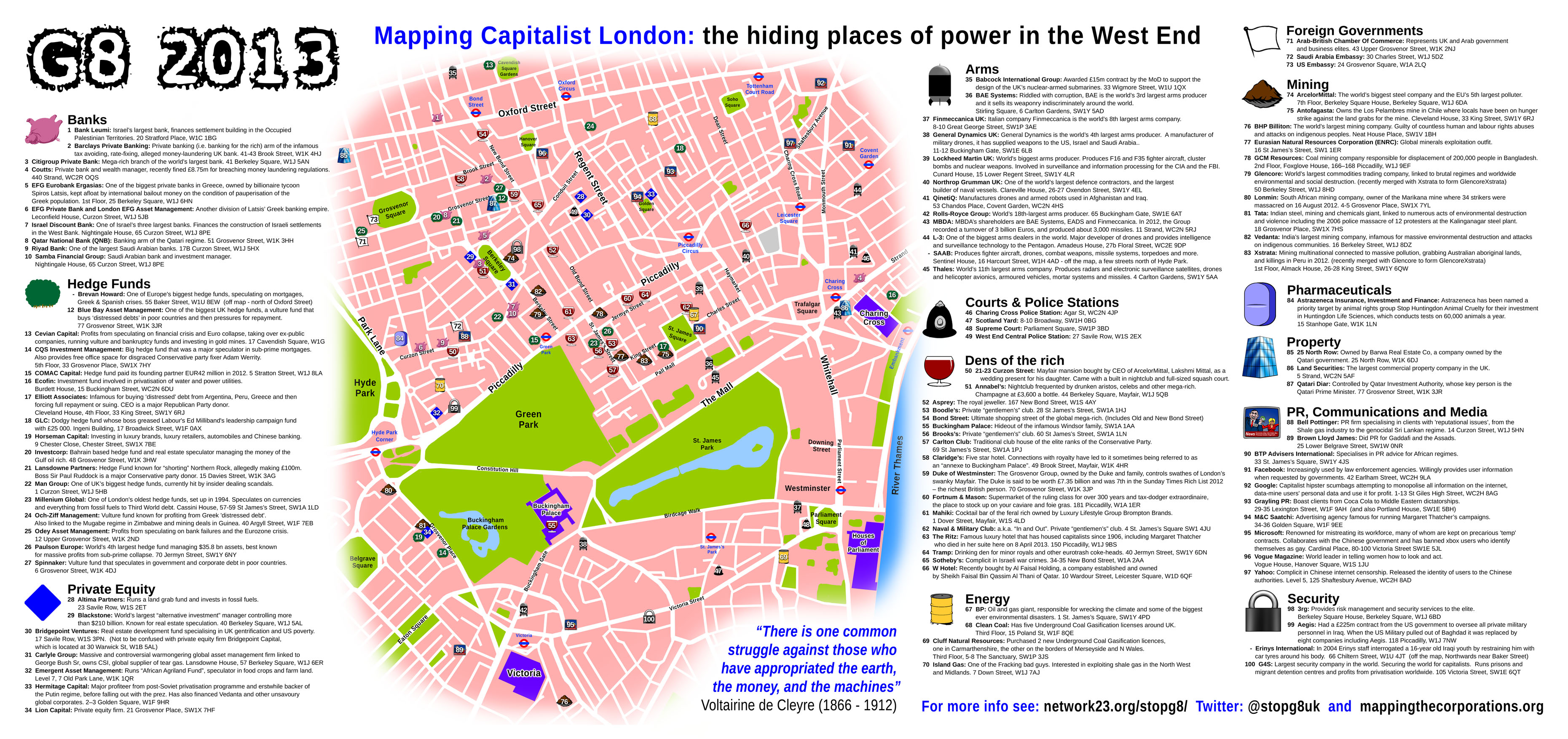
As part of the build-up one of the main organizing groups – Stop G8 – issued what they called an ‘action map’ with ‘100 addresses of power, tyranny, and exploitation’ across the West End of the city. Included amongst these ‘hiding places of power’ are banks, hedge funds, private equity firms, arms companies, security firms and what they call ‘dens of the rich’.
The main aim of the map is to facilitate protests in and around the West End, and the wider media have been more than happy to cover its existence. The Financial Times led with ‘London hedge funds ‘mapped’ by G8 protesters’, Reuters with ‘Anti-G8 protesters issue map of London capitalist targets’ and the Evening Standard with ‘G8 anti-capitalist protesters target ‘100 addresses of power’ in West End’. The FT even had an anonymous quote from a concerned chief operating officer of a hedge fund saying that ‘[the map] is being taken seriously’ by London Metropolitan Police, and even smaller hedge funds who hadn’t been mapped were still circulating it in case of trouble. So although the map has ostensibly made visible a host of ‘unethical’ global corporations, even those that haven’t been mapped are still fearing the worst.
The Stop G8 website will issue some further details on the carnival in due course, including a main demonstration route for the day, and a more detailed map of the area in anticipation of independent action.
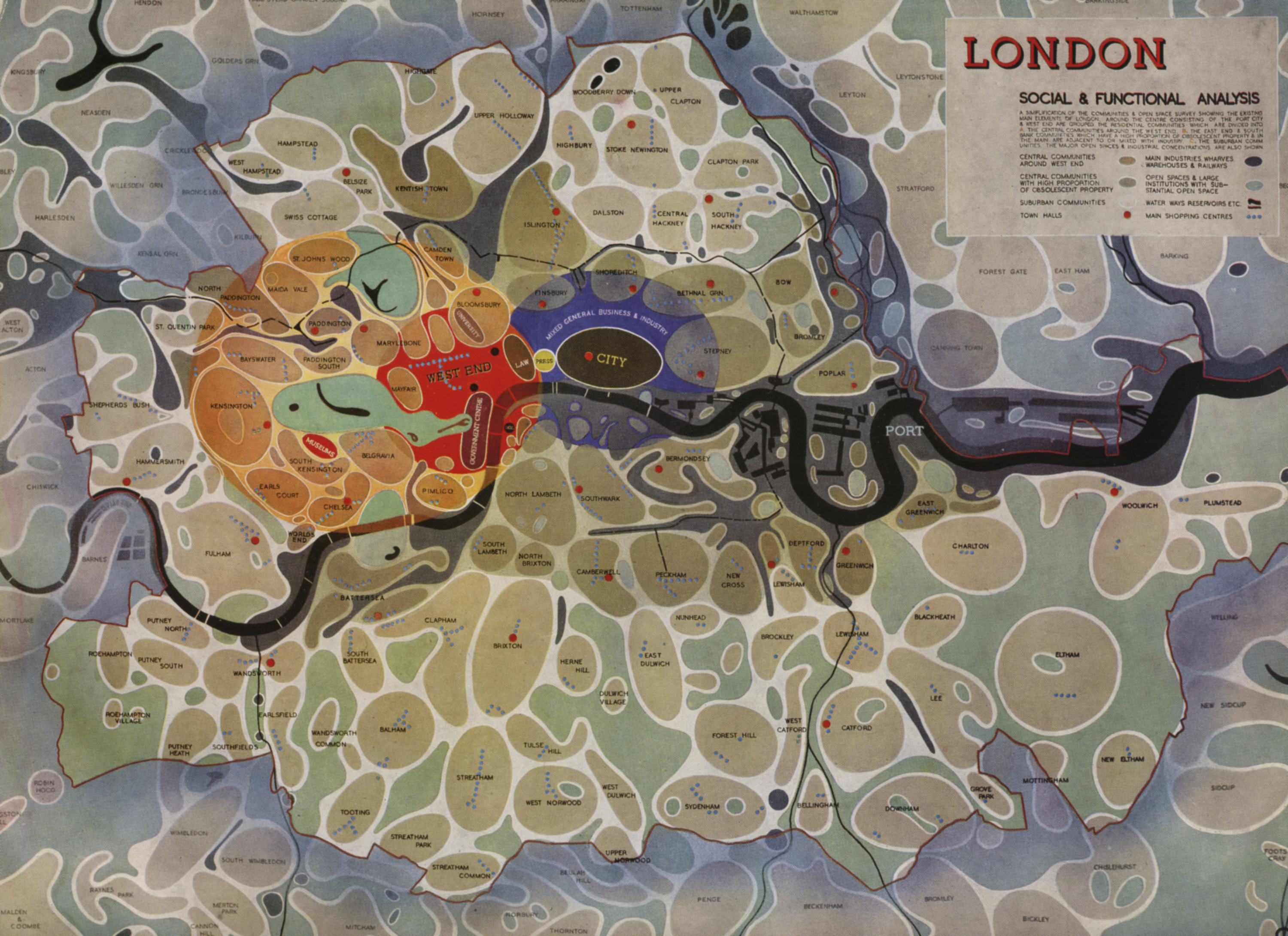
The beautiful map above is part of the press pack for Utopia London (2010) and was produced for one of the two Patrick Abercrombie plans for the city in the 1940s. The County of London Plan(1943) was commissioned by London County Council and authored by Abercrombie and fellow architect John Henry Forshaw, whilst the Greater London Plan (1944) was drawn up a year later by Abercrombie alone. Both were responses to the pertinent wartime urban problems London was facing such as overcrowding, poor housing quality, family poverty, disease and traffic congestion. So at varying scales, Abercrombie’s plans for designed to foster a new type of urbanism. One borne out of the ensuing post-war virtues of order and dignity.
As the map shows, Abercrombie’s vision was centred around new towns. These multiple city blobs, resembling spores on a petri dish, were designed to re-distribute meaningful, liveable space in and around the fringes of the densely-built ‘City’ and West End areas. They were to form the pivot for the re-zoning of London following the devastating effects of the Blitz. Note also the bacterial presence of wharves, warehouses and railways in the dark grey. Incidentally, the Thames itself is an even darker shade of grey. The London Tube Map of the present day depicts a fresh, light blue Thames in stark contrast to the murky oil slick of Abercrombie’s. The London of the 1940s was one of deficiency and lack.
In fact, one of the key themes of the County of London Plan was a provision of green space. A fantastic flickr set of scans from the plan are available to view online, with a double page spread devoted to the visualization of an ‘open space deficiency’ in the city as well as a proposed ‘open space plan’ to combat it. On the former, areas with no parks within a 1/2 mile walking distance are shadowed in black. It’s a frighteningly large expanse stretching across the Thames, swallowing up swathes of Southwark, Camberwell and Peckham to the south, parts of Stepney, Bethnal Green and Shoreditch to the north-east, as well as Finsbury, Camden Town and Islington to the north-west. Only Hampstead Heath prevents further areas falling into the abyss.
The new arterial ‘parkways’ as Abercrombie and Forshaw name them, were to be designed to address two issues; both the traffic congestion of central London and the green space deficiency of peripheral towns. The authors wanted to foster a kind of decentralized London consisting of local amenities such as shops, markets and new residential areas. On the open space map of the County of London Plan, these parkways were so-called because they were to create a kind of linear green space alongside the circular road network, ensuring that inhabitants of the dark spaces would see light. Segregating different speeds of road user was to be the dual solution to traffic congestion and open space. London citizens could walk along tree-lined avenues without fear of being hit by extra-urban traffic, elevated to high-level roads (for more click here).
The rhetoric employed by Abercrombie and Forshaw questioned a loss of opportunity for London to rebuild not only its architectural integrity but also its vision and its imagination, and this call to arms asked:
can we plan our London; give it order and efficiency and beauty and spaciousness? Can the County of London Plan become the real plan of London? (p. 12)
Abercrombie’s plans were never fully realised. They were designed as optimistic renderings of a post-war London, functioning and circulating as material hopes for its citizens. An urban aspiration or utopia.
For more, watch a clip from the BBC’s Britain From Above series on ‘The Changing Face of London’. Below is a promotional film – ‘The Proud City‘ designed to garner support for the Abercrombie Plans. Further discussion on the plans can be read here.
The Changing Face of the North West: Modernist Dreams and Utopias
The Manchester Modernist Society, the North West Film Archive and Manchester Metropolitan University Geography are pleased to bring to the City Art Gallery a curated programme of archive films charting the transformation of the North West landscape through the aspirations of 20th Century dreamers, citizens and planners.
Every third Thursday of the month we will present a film screening from 6.30 pm in the City Art Gallery Lecture Theatre on Mosley Street, central Manchester. A specialist presenter will introduce each screening, followed by informal questions and answers. Each event is free, but pre-registration is essential as places are strictly limited. Refreshments will be available for purchase in the cafe.
As part of the RIBA lovearchitecture festival 2013, Manchester City Art Gallery, Manchester Modernist Society, Geography at Manchester Metropolitan University and…
Sarah Elwood and Agnieszka Leszczynski‘s 2012 Transactions paper is open-access and available here. Worth reading if, like myself, you’re interested in the political agency of new spatial media. Cuts through the evangelical b*llshit in my opinion. Here’s a good quote that speaks of the need for more empirical research into the manifold deployments of spatial media and resulting knowledge assemblages:
Th[e geoweb] literature suggests the need to be attentive to how digital visual artefacts frame audiences’ interactions with the presented content, to the visual practices enabled by these emergent artefacts (e.g. watching, playing, surveilling, controlling, gaining awareness), and to the visual epistemologies that emerge within these practices. What has yet to be undertaken are grounded studies of the substantive practices emerging from activist and civic engagement applications of new spatial media, to consider the nature and genesis of the epistemological politics advanced through these initiatives, and the extent to which they re-inscribe or depart from engagements with other kinds of geographic information technologies. (4-5)
N.B It’s the first academic paper I’ve come across that has expressly mentioned the Sukeyprotestapplication – albeit in the endnotes.
“The devices that once populated the creepy dystopian futures of science fiction have broken through into our daily reality.
Drones of dozens of different types are becoming a part of everyday life. They scout our public (and private) spaces, carrying out surveillance or reconnaissance in the service of nation states and as unmanned robotic tools, armed with missiles and bombs, acting in defence of “national security”.”
Includes Bit Plane by Bureau of Inverse Technology (Natalie Jeremijenko and Kate Rich), Parallel by Lawrence Bird, The Private Life of a Drone by Patrick Lichty, Lines by Dave Miller and Gavin Stewart, TELEWAR by Dave Young and The Force of Freedom and Moveable Borders – The Reposition Matrix by Dave Young. The latter forms the central installation for the whole exhibition:
“The Reposition Matrix aims to reterritorialise the drone as a physical, industrially-produced technology of war through the creation of an open-access database: a ‘reposition matrix’ that geopolitically situates the organisations, locations, and trading networks that play a role in the production of military drone technologies.”

 London will see a ‘Carnival Against Capitalism’ take place in 9 days time to coincide with the 39th G8 Summit taking place in Northern Ireland from 17th to 18th.